Map of PPP Funding
Please be patient.
All data is first downloaded locally for viewing (128MB 79MB!). This is a single static HTML file!
Click here for Full screen visualization
GIF of Interactive Map
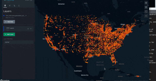
Legend
- Color of the points is based on the approx loan size. The darker the color the higher the loan.
- The size of the points is based on the # of jobs retained. The larger the number the larger the dot.
You can edit these parameters and use the built in filtering functionality yourself!
Data Disclaimer
Data is based on the csv from SBA PPP Raw Data: https://home.treasury.gov/policy-issues/cares-act/assistance-for-small-businesses/sba-paycheck-protection-program-loan-level-data [661,218 records total]
As reported this dataset is a big mess and I could not geocode every record. Currently I have 486,701 records which is 73.6% of the original dataset. I’m not completely certain if these records are correct and my current geocoder method wasn’t working, or if there are actual mistakes in the data, my guess is the latter. I might try to take the remaining records through Google’s Geocoder since I used the US Census’s geocoder from the first run. (Getting value for my tax $’s :))
Enrichment
- Added an estimateLoan column which is an average of the loan range values
- Added the textual description of the NCID code for every firm.
## Updates 7/9/2020
- Removed columns [RaceEthnicity, Gender, Veteran, NonProfit, loanRange, DateApproved] to reduce data loading times and increase performance.
- Removed full addresses and changed to State and Zipcode columns. Allows for filtering by State and Zipcodes.